WATERSHED DISTRICT
Middle Fork Crow River

Calhoun Area Water Control and Habitat Enhancement Project
 |  |
|---|---|
 |  |
 |
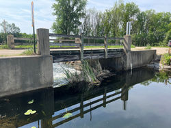
The Middle Fork Crow River Watershed District (MFCRWD), in partnership with the Minnesota Department of Natural Resources (DNR) is leading a major enhancement initiative within the Dietrich Lange Wildlife Management Area (WMA). This project aims to renovate aging water control structures including the Lake Calhoun diversion structure and the Lake Calhoun outlet dam. The centerpiece of this effort is the renovation of these two outdated dams with new rock arch rapids and replacement of the timber bridge with a more modern vehicle bridge which includes a pedestrian walkway. These new structures are located along the Middle Fork Crow River. These naturalized features will maintain necessary court ordered water elevations while re-establishing ecological connectivity between the lakes, benefiting fish passage and habitat quality.
The project is supported by $2 million in secured funding from multiple sources. This includes $1.425 million from the Legislature’s Get Out MORE (Modernize Outdoor Recreation Experiences) initiative, $125,000 in Wildlife Betterment of Lands bonding, and $450,000 in Natural Resource Asset Preservation bonding to support bridge replacement. In addition to modernized outdoor infrastructure while improving ecosystem resilience, the upgrades will provide increased shore fishing opportunities for anglers.
Construction and associated closures are scheduled to begin in late summer, with the project area expected to be closed for access around September 2026. This collaborative endeavor reflects a shared commitment to sustainable natural resource.

Figure 1: Project site overview showing the location of dams and connecting water bodies.

Figure 2: Sample rock arch rapids similar to what is being constructed between Lake Calhoun and Green Lake.
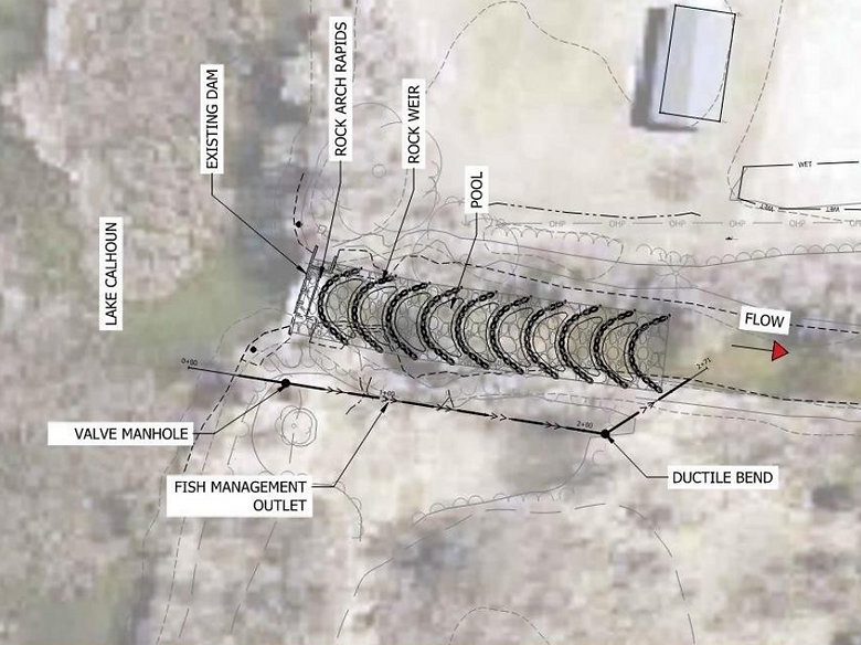
Figure 3: Stantec blueprint rendering of the natural rock arch structure along with the dam systems to maintain state mandated water level.
Calhoun Dam Ice Out Closure

The Calhoun Boat Landing will be CLOSED starting Wednesday, February 4th, 2026 for the reminder of the winter or until further notice. The Township landing on East Calhoun Rd is open for lake access. During this construction time the DNR bridge and access road to the landing will be closed for the remainder of the winter or until further notice. The Township landing at 160th St NE and E Calhoun Rd is available for use to vehicle traffic. We appreciate your patience cooperation. For any questions, call Andy Johnson at 320-796-0888 or email andy@mfcrow.org.